 Dam failure can mean catastrophe; for people, property and far more.
While there has been no loss of life from dam breaches since 1925 in the UK, fatalities still occur overseas.
A risk-based approach to dam breach assessment puts public safety at the top of the list.
Safety first
In 1975 the Reservoirs Act was adopted to promote the safety of large raised reservoirs in England, Wales and Scotland. It was updated in 2014.
A number of panels of appropriately qualified engineers are maintained, and any reservoir within the scope of the Act must be designed, or construction supervised, by an engineer on the appropriate panel.
Panel engineer categories
- All Reservoirs – able to design, supervise and inspect any reservoir.
- Non-Impounding Reservoirs – able to design, supervise and inspect reservoirs that do not obstruct a watercourse.
- Service Reservoirs – able to design, supervise and inspect closed reservoirs, principally large water distribution structures.
- Supervising Engineers – able to design, supervise and inspect any reservoir, and request inspection by a member of the appropriate panel if necessary.
Following construction, a different panel engineer must inspect the reservoir within three years. During the lifetime of the structure, a member of the Supervising Engineers panel must be retained to carry out regular inspections, usually on an annual basis.
An engineer from an appropriate panel must inspect the reservoir at least every 10 years or when requested by the supervising engineer. The inspecting engineer has the authority to instruct work to be carried out for the safety of the reservoir if necessary.
A Scottish perspective
Reservoir safety in Scotland is governed by the Reservoirs (Scotland) Act 2011.
This Act was designed to ensure increased public protection from the risk of reservoir-induced flooding, while ensuring that the owners of reservoirs are treated fairly.
Regulation was shifted from a capacity-based approach to one based on risk.
All controlled reservoirs in Scotland must be registered with the Scottish Environment Protection Agency (SEPA) and be designated a level of risk to human life, property, and critical infrastructure based on a framework provided by the Act.
Risks are categorized as high, medium and low, with higher risk requiring a greater level of regulation and control. This means that previously unregulated reservoirs may now be regulated if they are high risk, and larger reservoirs that are low risk require less regulation.
Panel engineers are responsible for supervising, inspecting and advising on reservoirs during construction and their operating life, if they pose a risk to the public.
Risk designations will be re-assessed every six years to tie in with the Flood Risk Management (Scotland) Act 2009. This ensures that the latest information will be used.
Enter WHS
We were commissioned to assess the flood risk of a number of dam failures in Argyll and Bute, following SEPA guidance:
- Airigh nan Lochan Dam, Airigh nan Lochan Upper Dam, and a proposed dam at Glenure House, all in the Glencreran Estate approximately 6 km upstream of Loch Creran.
- a proposed dam located 3 km upstream of the Bay of Strachur (Loch Fyne).
The dams vary in size and capacity, so they each needed to be assessed to quantify flood risk in the event of a breach, taking into account a range of downstream receptors.
The receptors listed by SEPA are:
- Human health
people
community - Economic activity
businesses
transport
agriculture - Environment
- Cultural heritage
We used a two-stage approach:
- Stage 1 Risk screening
- Stage 2 Dam-breach modelling and mapping
Stage 1 Risk screening
We assessed the risk at each dam site, using SEPA risk designation criteria. This included scrutiny of aerial imagery and detailed OS mapping.
Where Stage 1 confirmed that flood maps were required, then hydraulic modelling was undertaken to create flood maps in Stage 2.
Flood maps quantifying the consequences of a dam breach must be produced for each associated dam when:
- a reservoir holds over 10,000 m3 of water
- risk to downstream receptors is of medium or greater risk.
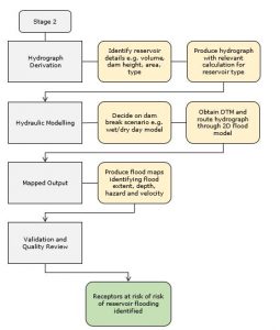
Stage 2 Dam breach modelling and mapping
The process flow chart below outlines the process.
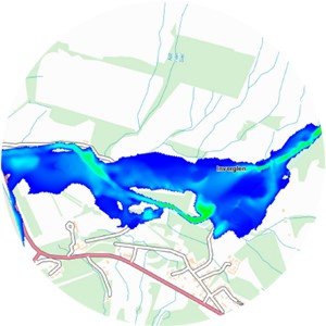
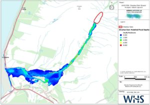
The map below shows the modelled flood depths following a dam breach of Strachur reservoir.
The last word
WHS has undertaken numerous dam-breach modelling assessments in the UK using current best-practice methodologies.
We have a good understanding of assessing dam failures in the UK.