 A victory for common sense with flood mapping in Wales
The Welsh Development Advice Map is to come alive. In April 2017 it is due to be aligned with the Natural Resources Wales flood map. Regular updates in future will keep the two maps in harmony.
Every developer in Wales knows TAN15, right?
Technical Advice Note 15: Development and Flood Risk (TAN15) supports Planning Policy Wales. Introduced in 2014, it promised a ‘common sense’ approach, supported by the Welsh Development Advice Map (DAM), itself based on the NRW flood map current at that time.
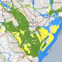
The DAM is the first port of call for local planning authorities assessing flood risk, and classifies land into three zones of risk. Different zones require different planning actions, so correct zone classification is critical to development.
Holding back time
The intention was to improve and refine the DAM in future, but things didn’t work out quite like that. While the NRW Flood Map has benefited from quarterly updates, the DAM has not.
The DAM was last updated by the Welsh government two years ago (January 2015) and two years before that.
This means that although modelling techniques have been refined and our understanding of flood risk has improved across Wales, the DAM has not reflected this. Conflict and confusion between the static DAM and the up-to-date NRW flood map has caused great difficulty at many stages of the planning process. Disagreement about the extent of flood-risk zones has meant delays and costly protracted negotiations.
Precision in flood mapping is definitely not straightforward, but there have been notable examples where the DAM’s zone classification is known to be incorrect and based on out-of-date data, and it still prevents development.
Even when detailed site-specific FCAs show that flooding issues can be appropriately managed, proposed developments have been objected to because of the DAM.
A recipe for serious frustration.
A brighter future ahead
In 2017, NRW are taking over the role of maintaining and updating the DAM.
The NRW flood map and DAM will both be updated quarterly and they will share consistent data. The next NRW flood map update is expected in April 2017 and the DAM will be updated at the same time to reflect all changes.
New modelling techniques and improved understandings of flood risk will be incorporated into the DAM. Development decisions will be guided by the best available information and developers can be much more confident in selecting appropriate sites to take forward.
The last word
The original intention of TAN15 is being realised and we welcome this.
The Wales National Flooding Conference last week confirmed that things are on track… Let’s hope the anticipated timescales are achieved.