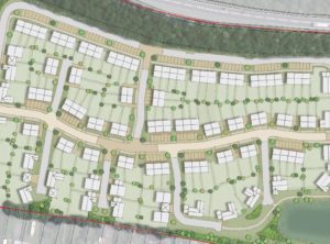
 Flood map data for the flood zone of a minor watercourse in Nottinghamshire restricts the number of properties in a planned 87-unit housing development.
Flood map data used for planning purposes is sometimes based on coarse modelling techniques that can overestimate the extent of flood zones.
Time for WHS
The hydrology of this small catchment was relatively complex as it was bisected by a canal and included significant urban development and artificial drainage.
We recommended a detailed modelling study to the client.
Proactive liaison with the Environment Agency (EA) from the outset was key. We proposed a methodology and agreed it with the EA before starting any modelling.
We completed a topographic survey of the watercourse and downstream culverts, and constructed a 1D model of the local watercourses. Our modelling demonstrated a reduction in the flood zone.
Result: Planning consent on first submission to the local planning authority. Space freed up for an attenuation pond as part of our proposed surface water drainage strategy, allowing more properties to be developed on the site.