2007: the summer floods affect several key substations, highlight their potential vulnerability to major flood incidents and prompt a national review. Network owners assess levels of flood risk to substations in their area with the Environment Agency (EA) and make a prioritised list of substations at risk of flooding.
For network owners to improve the resilience of electricity supplies during a flood incident, a clear and consistent view of the level of risk to be covered is needed. Robust flood depth data is also essential to assess flood risk properly and decide on appropriate substation protection, but coverage of flood depth and more detailed data is generally limited.
As part of a 10-year programme under the Distribution Price Control Review 5 (DPCR5), significant funding was provided for network owners to invest in flood protection measures at key UK sites.
Time for WHS
WHS needed to assess flood risk and resilience options across a number of regions.
In our initial reviews of flood defence requirements based on previous assessments, we found that several had significantly over-estimated design flood levels. With our predictions, the network owner was able to plan more pragmatic flood protection.
Our systemic approach used Geographical Information Systems (GIS) to import and analyse the available data for over 200 UK substations. We developed a cost-effective study method, combining publically available data with existing hydrologic and hydraulic modelling. We also surveyed the critical asset levels of substations topographically, and watercourses where needed.
We established the flood risk for each substation and determined a flood level for those considered to be at risk of flooding. The design flood level at each substation incorporated levels of uncertainty, as recommended by the Energy Networks Association (ENA), and uncertainties due to climate change during the lifetime of the assets.
Our modelling approach was tailored to the needs of each site, maximising value to the client and minimising the amount of topographic survey required. At some sites we could extend or adapt EA-supplied model data and at others we created bespoke hydraulic models, applying 1D/2D or linked 1D/2D approaches as appropriate.
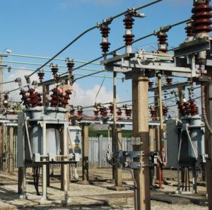
We compared predicted flood levels with the position and type of equipment at all sites.
Result: The network owners were able to review the flooding impact on each primary and higher-voltage substation and allocate resources for flood protection as needed.
At sites where critical assets and continuity of power supply were threatened, the most appropriate flood protection systems could be decided on.